

Our Crowdfunding Groups

We have met out goal, thanks to the generous support of our donors and an equally generous match from Monarch Watch. Thank you!!!! But there is more to be done. The app has an annual cost for keeping up with operating system upgrades as well as paying for the cloud based server for the data. Every additional donation gives us a longer time-series. In science, one year is good, two is better, and three is, well, awesome. So, please help us extend these observations into the future!
Monarch butterflies are among the most charismatic insects in the world. Their large orange and black wings are immediately recognizable, perhaps as the only butterfly that a person can name. They are the state insect or butterfly of seven U.S. states and one appears on the hat of Sitting Bull in his classic picture from the 1880s. As part of their life cycle, they conduct an epic migration across North America using several complex compasses to steer them across 1000s of kilometers to their overwintering sites. Work by Dr. Gary N. Ross has documented their presence offshore on oil platforms in the Gulf of Mexico during their fall migration south and suggests they are important resting areas in a possible trans-Gulf migration. Can they complete the migration across the Gulf in the fall? Is this still an important phenomenon after years of declining monarch populations? Do they perish in the waters of the Gulf of Mexico? For the overland migration, do the compass directions change during the migration? Can they correct for being blown off course? We are building a tool to help us answer these questions. Intrigued? Here's how you can help.
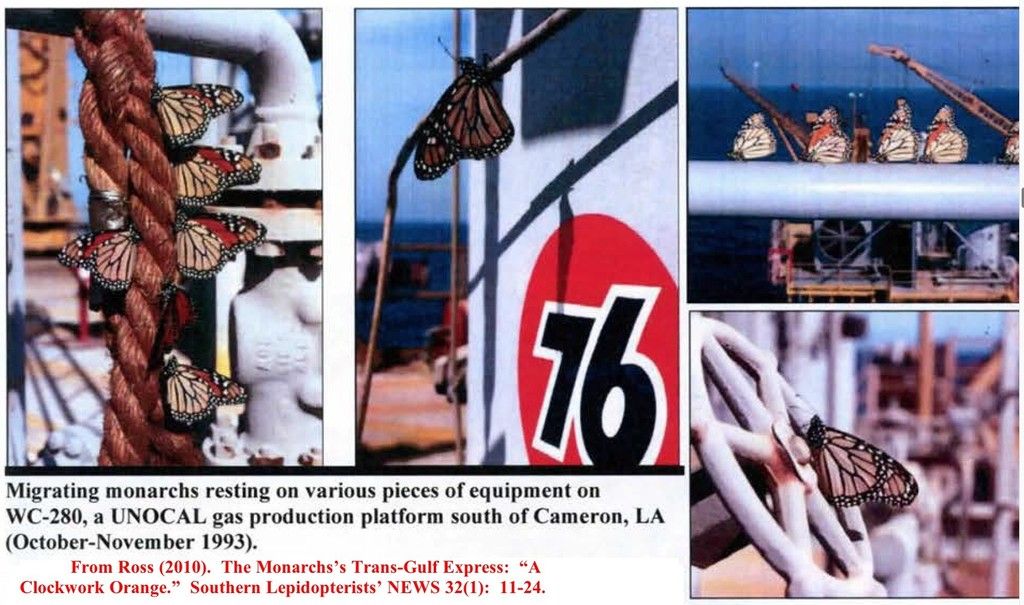
Dr. Villareal's questions center on how oil platforms may serve as stopping points in a journey across the Gulf of Mexico. There are many unanswered questions. Is there a corridor across the northeastern Gulf as suggested by Dr. Ross? Does this phenomenon still exist offshore? While rigs are even more widely distributed than in the late 1980s, there are few (if any?) records being kept of monarch distribution on them. Most importantly, when the monarchs leave the most southerly rig in the crossing, what happens? What direction are they going, and can we get obsevations of them flying ashore? These are very simple questions that require numerous observers to answer. Got an observation of monarchs occurring over water or around island? Share it on our Facebook page: https://www.facebook.com/marine.monarchs.
Dr. Taylor has long studied migration patterns trying to determine where the monarchs navigational systems are actually directing them. Monarchs use several, complex navigational systems including a sun compass with an internal clock to compensate for sun motion as well as a magnetic field sensor that directs the monarch using the angle of the Earth’s magnetic field. The evidence suggests that the flight path using the compasses is very specific but there is a need for a large, widely distributed database that records both body alignment (where they want to fly), and the vanishing bearing. That is, their bodies may be flying in one direction, but the wind plus their motion is moving them at an angle to that. It’s much like an airplane crabbing in the wind, only the monarch is probably pointing to where it wants to go, but actually goes where the weather allows it to go. At the present, there is no way to record these two flight trajectories across large segments of the migration path. As a result, we do not know if, how, or when monarchs make decisions during the migration about using the different compasses to arrive at their overwintering sites. We also don’t know if these compasses allow corrections during the migration to account for being driven off course.
Data collection on this scale is a challenge. Oil rigs are hard to get to, are scattered over the Gulf, and number over 4,000. Rather than trying to put a few, a happy few, observers on platforms to support Dr. Villareal's work, we are creating a mobile app that will permit offshore citizen scientists to record observations and help build a large database on their movements. Dr. Taylor's program on land needs flight angle components to study migration compasses on a scale never before possible. We have protoyped a beta version of an app to help us do this. It runs on the iPhone using Spotter Pro, a form based application platform that specifically serves the needs of citizen science. The beta version has most of the functionality we need. Right now, the beta version records the time, day, lat/long, numbers of monarchs, the recording time, their behavior, and a space for comments. However, there are a lot of improvements we need to incorporate for it to be fully functional. These are items like weather observations captured for the time of recording, compass headings for both body direction and movement direction, ability to upload a picture, recording altitude ( pilots see monarchs).
The app will provide a new tool for addressing these questions since it can record both these flight vectors (movement and body direction) very quickly, and then capture the weather information at the same time. The data is stored until cell signal is restored, a valuable function when offshore. At least it is valuable if we get sufficient support! This is all made possible by the design of the app. We are focusing on rapid data acquisition to support both busy offshore citizen scientists as well as for high speed data acquisition for research purposes by dedicated local observers. It is a powerful combination. Within the space of a few seconds, an observer will be able to capture locations, time, weather, flight direction, body direction, number and behavior. A key aspect is that this app can be widely distributed. These studies need vast amounts of data and this can only be achieved if dedicated volunteers have suitable tools.
Like to try the beta version? Scroll to the bottom of the page for information.
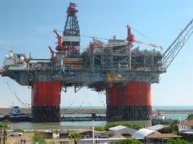
Thunderhorse, one of the largest rigs in the world, being towed to sea in 2006. There's a lot of room for butterflies.
When completed and distributed, the data will show us maps of both body alignment (where their compasses are telling them to go) as well as their flight vectors (where the weather allows them to go). This will be coupled to temperature, humidity and cloud cover information in a grand presentation across N. America. It’s a bonus for the offshore program as well since observers will be able to report where monarchs head off to in the morning as they ascend from rigs.
When we have the app built, we will distribute it to offshore oil workers, fishermen, pilots, you name it. We would also like citizen scientists to collect data along the Gulf coast so we can match up offshore movements with what is happening along the coast. This would best be done using the Journey North app since they have a long record of the fall migration on land that is much larger than what we could collect. Even if you can't use our app, use theirs! Starting with the fall migration in 2015, we will have the first extensive coverage of the entire Gulf of Mexico with concurrent weather information. Dr. Taylor's program will use observers in organized birdwatching groups as well as other volunteers to record the critical flight trajectory information. The fall migration is the most reasonable time to expect a significant impact offshore and with enough contributors, we can record where they are not (looking, but not finding them). This is an important part of confirming Ross's idea of a "corridor' in the Gulf of Mexico during the fall migration. This project can only work with widely distributed observers in the Gulf of Mexico, and North America, and only if they have a way of reporting the data. That's what this project will do: create a way for citizen scientists to gather the data we need and to do it in a manner consistent with the needs of working offshore.
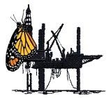
Cover art for the offshore iPhone app: Our logo. Yes, it is marine centric, but Villareal's an oceanographer. What do you expect?
There are several reasons. This project depends entirely on the support of many individuals. There is no way to get funding for observers to sit on oil platforms and wait for a butterfly to whiz by. Seriously, not even the government would fund this. The existing tools for recording flight and body direction are primitive. People run after butterflies with a compass. We aim to change all this, but the project can’t work without a way to collect and upload the data. The folks that are offshore are doing dangerous jobs and they can’t be tied up with forms and paper. So, we have to create a highly specialized app for them, something they can just tap a few times and forget about. And that’s why we need you.
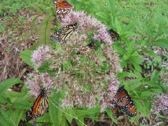
Monarchs, queens and a gulf fritillary nectaring.
Useful sites on the biology of the monarch with pictures:
Everything you want to know: http://www.monarchwatch.org/
Watch the migration each spring and fall, many educational resources: http://journeynorth.org/
More on milkweed: http://www.saveourmonarchs.org/
How to download and use the beta version. Warning: you may become addicted to it. The app will expire in a few months so don't put anything critical in it. You will only be able to see your data due to security concerns.
To try it out: 1. Go to https://spotter.conserve.io and create an account (use the group code GMMS). There is currently a problem with using Safari, so try this using another browser, please. 2. After registration, check your email for an activation link 3. Once the account is active, download and open the Spotter Pro app on your phone or iPad 4. Tap the user tab and login with your new account info
To try out a trip and observations: 1. Tap on the Trips tab 2. Tap on the '+' symbol beside Trips in the top left 3. You can enter your name under 'data collector' or just tap 'save' (you can edit these fields at any time prior to uploading the trip 4. Tap 'Start' in the middle bottom to activate the trip and start logging GPS location 5. The app will enter the map view, tap on the 'Sightings' tab on the lower left and then the '+' to the right of 'Sightings' in the top left to add a sighting 6. Once you save a sighting, tap on the Recorded trips will show in the Trips menu when you aren't in an active trip and will show whether they have been uploaded to the Spotter server. To upload a trip, tap on it and then tap the Upload button at the bottom of the screen. Prior to upload, you can edit a trip with the edit button. Due to security concerns, you will only be able to see your own data. You can use the same login as in the app at http://spotter.conserve.io to view uploaded data, download a CSV of sightings, etc. Please note that accounts and data will be deleted on 15 May 2015. Don't put anything ciritical in this data set. A tattered and worn, but determined, spring migrant returning after overwintering in Mexico. 
A gift at this level is paving the way for a successful project. Somewhere, someone in the Gulf will be looking at a monarch and recording its presence. That's your butterfly!
Your gift will lead to enhancement of application features, such as altitude, flight vector and butterfly body direction. Now your butterfly has movement!
A gift at this level will allow pictures to be uploaded with location data. Perhaps someone will see masses of roosting butterflies on a rig or ship. Pictures tell a mighty story and your gift can help share the story.
Fly free and help us include weather information in the report. Strong winds from the right direction can waft the monachs over vast distances. They even make it to England by the agency of the wind!
A donation by you at this level will give us a year's worth of service and support. 2016 could be your year! Imagine, thousands of observations flowing into the database because of your gift.
Your donation will take this to the next level and allow an Android version to be built. This is enabling far more than butterfly observations. It will permit the app's modular functionality to be applied to any problem using the Android OS. We need 3 donors!
